


site search
online catalog
MITCHELLES MAP, NO. 12 – “MAP OF THE CHIEF PART OF THE SOUTHERN UNITED STATES AND PART OF THE WESTERN”

$50.00 SOLD
Originally $95.00
Quantity Available: None
Item Code: 998-1209

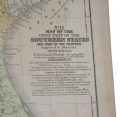
Engraved to illustrate Mitchelles School and Family Geography, by W. Williams. Published by S. Augustus Mitchell, 1852. 17.75 x 11.5”. Attractive colored map of southern states: North Carolina, South Carolina, Georgia, north Florida, Tennessee, Alabama, Mississippi, Arkansas & Louisiana, bounded on the east by the Atlantic Ocean, and on the south by the Gulf of Mexico. Superb antique, suitable for framing. [jp][ph:L]
~~~~~~~~~~~~~~~~~~~~~~~~~~~~~~~~~~~
THIS ITEM, AS WITH ALL OTHER ITEMS AVAILABLE ON OUR WEB SITE,
MAY BE PURCHASED THROUGH OUR LAYAWAY PROGRAM.
CLICK HERE FOR OUR POLICIES AND TERMS.
THANK YOU!
Inquire About MITCHELLES MAP, NO. 12 – “MAP OF THE CHIEF PART OF THE SOUTHERN UNITED STATES AND PART OF THE WESTERN”
For inquiries, please email us at [email protected]
Most Popular
Historical Firearms Stolen From The National Civil War Museum In Harrisburg, Pa »
Theft From Gravesite Of Gen. John Reynolds »
Selection Of Unframed Prints By Don Troiani »
Fine Condition Brass Infantry Bugle Insignia »
British Imported, Confederate Used Bayonet »
Scarce New Model 1865 Sharps Still In Percussion Near Factory New »
featured item
FOLDING MAP OF VIRGINIA – ID’D TO COLONEL JOHN TOWERS, 8th GEORGIA INFANTRY – WIA GETTYSBURG
This map was part of the wartime collection of John Towers, Colonel of the 8th Georgia Infantry and comes to us in a good condition given its age and use. This high-quality map is a Lloyd’s Official Map of the State of Virginia, predating the… (846-561). Learn More »