


site search
online catalog
FOLDING MAP OF VIRGINIA – ID’D TO COLONEL JOHN TOWERS, 8th GEORGIA INFANTRY – WIA GETTYSBURG
Hover to zoom


$2,250.00
Quantity Available: 1
Item Code: 846-561
Shipping: Determined by Method & Location of buyer
To Order:
Call 717-334-0347,
Fax 717-334-5016, or E-mail
This map was part of the wartime collection of John Towers, Colonel of the 8th Georgia Infantry and comes to us in a good condition given its age and use. This high-quality map is a Lloyd’s Official Map of the State of Virginia, predating the secession of West Virginia. It includes all counties and all major features, as well as demographic information to include census data on the population of whites, slaves, and free people. All geographic information used to compile the map was drawn from executive surveys in 1828 and 1859, as well as 1861 and 1862 surveys by Captain Angelo Powell of the US Topographical Engineers – a member of General Rosecrans’ staff. The map is also designated as the only type used by General McClellan to plan his Virginia campaigns.
Areas of the map have been annotated, with a section of 100,000 acres outlined and labeled in red near the southeastern border of West Virgina, and a penciled note of the scale of the map in relation to actual distance. Interestingly, 35 sites related to the Civil War in Virginia are underlined in dark red - places such as Harpers Ferry, White Oak Swamp, Fredericksburg, Petersburg, Port Republic, Newport News, and Alexandria.
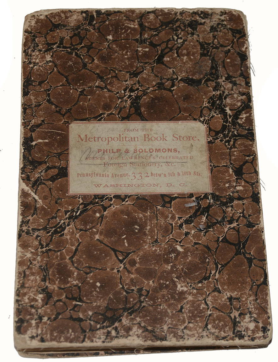
A printed publisher description notes that this model of folding map (cut into panels and affixed to a linen backing) was designed for military officers and copies can be acquired by said officers at no charge with free mailing. When folded, the front covers give it the appearance of a period book, with marbled artwork in black and shades of brown. A central label on the front reads “FROM THE Metropolitan Book Store. PHILP & SOLOMONS AGENTS FOR LAWRENCE’S CELEBRATED Foreign Stationery, &c. Pennsylvania Avenue. 332 betw’n 9th and 10th Sts. WASHINGTON. D.C.” Partially legible pencil writing is noted on the label.
The covers measure 8.1” x 5.1” while the separate panels (affixed to the linen backing) measure 8” x 4.8”. When unfolded, the map measures 31.4” x 47.75”, with a small, folding edge extension measuring 0.6” x 2” at upper right. The linen backing is in good, solid condition with virtually no fraying and only a small hole at the intersection of the far-right panels of the first and second rows (near the lowest portion of Maryland’s Eastern Shore). Some very small stains are present, with many appearing to be spots of ink bleed through or period glue. Some edges of the paper map panels show creasing and wear from folding. Some wear is present along the edges of each cover.
John Reed Towers lived in Anderson, SC until 1849, then became a merchant in Cass County, GA. He moved to Rome in Floyd County, GA in 1855 and had a metal casting foundry there.
When war came, he enrolled for service and was commissioned Captain of Company E, 8th Georgia Infantry on May 14th, 1861 in Rome, GA, and became Lieutenant Colonel of the regiment on January 28th, 1862 (to date from November 16th, 1861). He was captured on June 28th, 1862 near Richmond, VA, held at Fort Columbus, NY, then briefly at Fort Warren, MA before he was released for exchange on July 31st, 1862.
He was promoted to Colonel on March 26th, 1863 (to date from December 16th, 1862). He was wounded by a gunshot to his right hand at Gettysburg and again in June of 1864 in Virginia. He was surrendered and paroled with his regiment at Appomattox Court House, VA on April 9th, 1865.
After the war, he was sheriff of Floyd County from 1866-67. By 1870 he had a variety store in Rome, GA, and represented the county in the state legislature from 1873-74. He ran his metal-casting business until 1877, when he was appointed assistant keeper of the Georgia State Penitentiary. In 1885 he became the keeper, but retired the following year and moved to Marietta, GA. In 1900 he had apparently "un-retired" and was a salesman for a cotton oil manufacturer in Marietta until his death in 1903.
This is quite the unique piece, with ties to a Confederate officer who served in many of the major actions of the Civil War’s Eastern Theater. It would be a perfect addition to, or feature of, any collection. [cm][ph:L]
~~~~~~~~~~~~~~~~~~~~~~~~~~~~~~~~~~~
THIS ITEM, AS WITH ALL OTHER ITEMS AVAILABLE ON OUR WEB SITE,
MAY BE PURCHASED THROUGH OUR LAYAWAY PROGRAM.
CLICK HERE FOR OUR POLICIES AND TERMS.
THANK YOU!
Inquire About FOLDING MAP OF VIRGINIA – ID’D TO COLONEL JOHN TOWERS, 8th GEORGIA INFANTRY – WIA GETTYSBURG
Most Popular
Historical Firearms Stolen From The National Civil War Museum In Harrisburg, Pa »
Theft From Gravesite Of Gen. John Reynolds »
Selection Of Unframed Prints By Don Troiani »
Fine Condition Brass Infantry Bugle Insignia »
featured item
CONFEDERATE CAVALRY CAPTAIN’S FROCK COAT OF CAPT. EDWARD BIRD, “EFFINGHAM HUSSARS,” 2nd BATTALION AND 5th REGIMENT GEORGIA CAVALRY
This rare, identified, Confederate cavalry captain’s frock coat belonged to an officer who served from 1861 though 1865, rising from Captain to Colonel, with extensive action especially in Wheeler’s cavalry corps fighting against Sherman in the… (1179-232). Learn More »